Prepared by Caroline Wainwright, Declan Finney, John Marsham, David Koros, Linda Hirons
This year’s short rains over East Africa have been extremely wet, with some regions receiving more than double their usual rainfall. This has led to a constant stream of news stories on heavy rainfall, floods and landslides from Kenya, Ethiopia, Uganda, Somalia and South Sudan, with the regional snapshot from OCHA (United Nations Office for the Coordination of Humanitarian Affairs) suggesting that over 2.8 million people have been affected. Further to this, last week there were 4 tropical cyclones located in the Indian Ocean, which further exacerbated the heavy rainfall over parts of East Africa. The SWIFT project is working to build capacity for forecasting such events, so that communities can be better prepared for weather extremes.
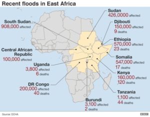
Cyclone Pawan made landfall over Somalia on Saturday 7th December, marking the highest number of cyclones in a single year in the North Indian Ocean since 1976 (8 cyclones this year). While it had weakened as it passed over the northern tip of Somalia it led to substantial impacts; rainfall totals exceeded 75mm1,2, heavy rain and high winds destroyed 50 homes2, and vehicles were swept away3, in a country where half a million have already been affected by flooding this year4.
Two days later, on Monday 9th December, Cyclone Belna made landfall over Madagascar, with maximum wind speeds of 165 km/h and risks of flooding. The Red Cross estimated that 260,000 people were at risk5. Thus far, nine people are reported to have died, and more than 1400 displaced6. Concurrently a third cyclone, Ambali, was located in the Indian Ocean, although it didn’t interact with any populated regions.
In addition to bringing heavy rainfall and strong winds to the regions where they make landfall, tropical cyclones also affect the weather in other regions. Cyclones don’t form within 5⁰ of the equator, so cannot hit Kenya directly, but the weather in Kenya is strongly impacted by the presence of cyclones in the Indian Ocean. However, the interaction is complex; Cyclone Idai in March 2019 coincided with a delayed onset of the rainy season and lower rainfall over Kenya, while Cyclones Dumazile and Eliakim in March 2018 were associated with enhanced rainfall. Recent work has indicated the location of the cyclones as a key factor in these effects7. Cyclones to the east of Madagascar (including Belna) seem, on average, to lead to equatorial westerly winds and enhanced rainfall.
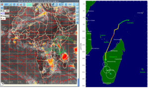
The figure on the right shows that the meridional (north-south) branch of the rain-bearing InterTropical Convergence Zone (ITCZ, dotted black lines) is currently over Eastern Africa. The moisture-bearing winds at medium level (green lines) converged with warm moist airmasses (associated with the warm sea surface temperatures) from the western Indian Ocean and Lake Victoria, which led to an increase in the energy available for storm formation and acted to concentrate convective systems toward southern Kenya. The southward trajectory of Tropical Cyclone Belna (shown in the right panel) deepened to a central pressure of about 994 hPa, with winds of 60 knots (110 km/h), which led to deep convection and enhanced precipitation over Kenya.
KMD issued a press release on the cyclone, stating that it would not hit Kenya, but would create favourable conditions for heavy rainfall over southern Kenya, and 5 counties were “put on alert”8,9. New stories suggest that roads were cut off and a restaurant was flooded9.
The present conditions in the Indian Ocean are favourable for cyclone formation because sea surface temperatures in the western Indian Ocean are particularly warm, as the Indian Ocean Dipole (IOD) has entered an unusually strong positive phase10, which has contributed to the heavy rainfall during the short rains, and damaging impacts across the region.

In addition to warm sea surface temperatures, a sub-seasonal tropical atmospheric phenomena within the atmosphere which enhances convective activity, called the Madden-Julian Oscillation (MJO), has been active over Africa and the Indian Ocean at times over the past few months. In certain phases, the MJO can enhance rainfall over East Africa and increase the chance of cyclone formation and intensification over the Indian Ocean11,12. Other tropical waves, originating from convection in the central Indian Ocean may have contributed to the recent cyclone formation.
Thus far during the 2019 short rains, there have been 11 cases of severe weather predicted by Kenya Met Department (KMD), 1-2 days before the start of the events. Advisories/warnings were issued and disseminated to the disaster risk management authorities and other users for mitigation against adverse effects.
David Koros, from KMD commented that SWIFT testbeds have led to improved predictability skills for such events. He also noted “the high consumption of the weather information” by users, and collection of user feedback, implemented as part of the SWIFT user engagement package, including verification and validation of warnings issued, suggested that forecasts have “tremendously improved”.
The SWIFT project aims to deliver a step change in African weather forecasting capability to improve the forecasts for such extreme seasons as this year’s East African short rains, and high impact events such as the tropical cyclones. Recently, the SWIFT project held a testbed event in Kenya, bringing together forecasters, researchers and forecast users to co-explore the reliability of forecast information on the 1-4 week timescales to aid decision-making.
SWIFT aims to pull such developments of weather prediction to selected users in its testbed, demonstrating the value of improved forecasting to decision making on the ground. This will provide evidence to support mainstreaming of SWIFT research into operational practise across the SWIFT partner countries, and ultimately across other nations of Africa and in the wider tropics.
Another important activity of the SWIFT team is the preparation of reports on severe weather events, for example, on Cyclone Idai or on heavy rains in Kenya. These reports are available on our website here.
References
- https://www.accuweather.com/en/hurricane/trio-of-tropical-threats-steadily-developing-in-the-arabian-sea/639409
- http://floodlist.com/africa/somalia-tropical-cyclone-pawan-december-2019
- https://twitter.com/MoradNews/status/1203214914665492480
- http://floodlist.com/africa/somalia-floods-november-2019
- https://reliefweb.int/report/madagascar/madagascar-red-cross-teams-alert-ahead-cyclone-belna-s-arrival
- https://www.aljazeera.com/news/2019/12/deadly-cyclone-belna-landfall-northwestern-madagascar-191211092755338.html
- https://rmets.onlinelibrary.wiley.com/doi/abs/10.1002/qj.3698
- https://twitter.com/MeteoKenya/status/1204042649470218240
- https://www.the-star.co.ke/news/2019-12-10-five-counties-put-on-alert-after-monster-cyclone-lands/
- https://www.severe-weather.eu/news/unusually-strong-indian-ocean-dipole-australia-europe-fa/
- https://rmets.onlinelibrary.wiley.com/doi/full/10.1002/met.1475
- https://journals.ametsoc.org/doi/full/10.1175/JCLI-D-13-00483.1