By Dr Kamoru Abiodun Lawal (NiMet) for GCRF-African SWIFT
On 25 July 2020 Abuja city, Nigeria’s capital, experienced one of the worst floods in its history. This event was a consequence of build-up of clusters of mesoscale convective systems that started as early as the morning of 22 July 2020, through and up to 25 July 2020.
Precipitation started around 0200GMT on 25 July 2000 and lasted until after 1200GMT the same day. Reports from the meteorological station show that the rainfall measured at the station was more than 50mm. This is also corroborated by measurements from the Global Precipitation Measurement (GPM).
Damages to Lives and Property
Damages to property and loss of lives were reported all over the city, most especially at places that are closer to river banks. Bridges suffered structural damages and were almost washed away. Many people are still reportedly missing at the time of this report.
S2S Climate Forecast Provided Advance Warning
Before the event, the subseasonal-to-seasonal (S2S) climate forecast released on 20 July 2020 under the auspices of GCRF African-SWIFT specifically mentioned that, “widespread flooding is possible and should be expected, especially over the northwestern, central and the Niger Delta areas. Agricultural and human losses, over the low lands and river basins, are not ruled out.”
The forecast showed that Abuja was to expect rainfall accumulation of about 75–100 mm within 20-29 July 2020, and the probability of rainfall exceeding 50mm was 100%. This was expected to be about 15mm above normal, coupled with the anticipation of excessive soil moisture that would likely aid run-off.
The forecast was sent to authorities whose sole responsibility is to alert people of the impending flood, helping prepare areas in advance of heavy rainfall.
In-Situ Weather Observation
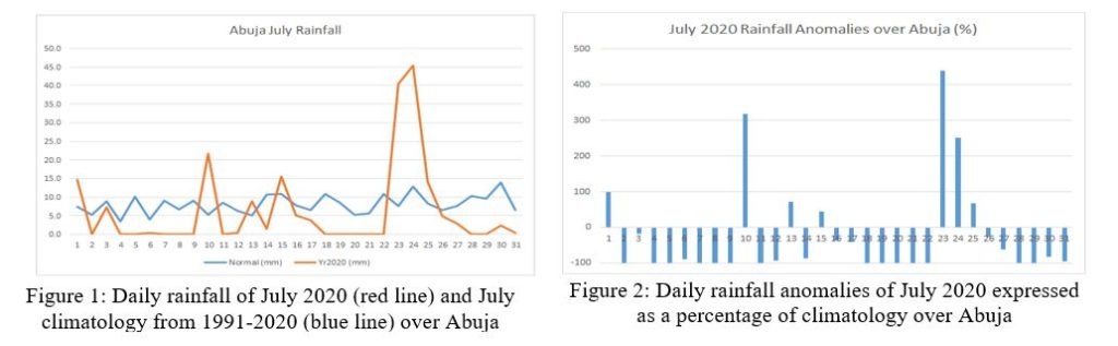
Intermittently heavy rain, which started on 23 July, continued on 24 July through 25 July, measured about 40, 45 and 15mm respectively (Figure 1). This translates to approximately 430, 250 and 60% above the normal rainfall (Figure 2).
Rainfall accumulation greater than 80mm is capable of saturating the top soil with water, thereby reducing the water intake capacity of the top soil, and consequently causing excessive run-off which resulted in the observed flood on 25 July 2020.
The Science Behind It
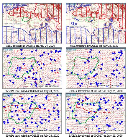
As the thermal depression along the northern fringe of Nigeria keeps deepening [from about 1003 and 1005hPa on 24 July to about 1002 and 1004hPa on 25 July], the wind flows right from the surface through 925hPa level to 850hPa level, becoming maritime and of westerly orientation.
There exists a well-established quasi-static through axis at 850hPa level around 10oN latitude, the presence of which aids the convective systems strong enough to produce continuous rainfall for three days consecutively.
About the Author
Dr Kamoru Abiodun Lawal is a Postdoctoral Research Fellow at the University of Cape Town’s African Climate and Development Initiatives where he is working on weather and climate event attributions in the southern and western African contexts. He is also the General Manager of the NWP Unit of the Nigerian Meteorological Agency and a key scientist participating in the GCRF African-SWIFT research project. Lawal’s research interests range from seasonal climate prediction, synoptic and computational meteorology to numerical weather prediction.