By Dr Peter Hill, University of Reading
New research demonstrates that satellite observations across Africa can be used to provide valuable forecasts of storm evolution in subsequent hours.
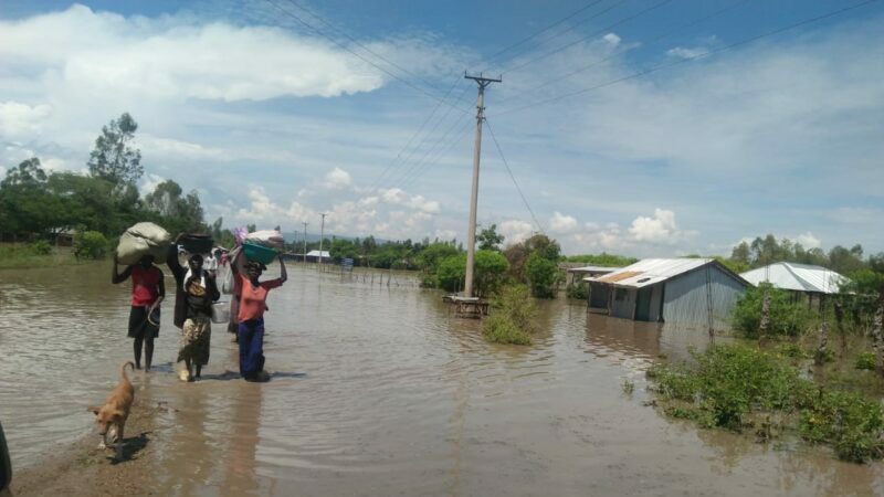
Large populations in tropical Africa are vulnerable to severe weather, often caused by intense storms that can generate heavy rainfall, strong winds and flooding. Forecasts can be used to take action ahead of such events, but for several reasons, forecasts from weather models often have very low skill in tropical Africa.
There is therefore an urgent need and opportunity to make short-term predictions – from 0 to 12 hours ahead – based directly on observations, something meteorologists term “nowcasting”. The simplest nowcasts take weather observations and extrapolate them forwards in time, using the assumption that the weather will continue to develop along the same trajectory as the recent past. Nowcasts can be crucial for severe weather events, providing timely information to enable authorities and the public to respond appropriately to safeguard lives and livelihoods.
One of the major obstacles to the use of nowcasting products in tropical Africa is a lack of rainfall radar observations, which are used for nowcasting in other parts of the world but are extremely scarce in tropical Africa. Passive satellite observations, which measure the naturally occurring energy that is emitted from the top of the atmosphere, provide a less direct measure of weather systems. Yet in the absence of other observations, this satellite data can provide vital information for nowcasting purposes.
The Global Challenges Research Fund (GCRF) African Science for Weather Information and Forecasting Techniques (SWIFT) project aims to enable African weather forecasting services to develop improved weather forecasting systems. For nowcasting purposes, the SWIFT project has made satellite-based nowcasts for tropical Africa freely available from a new website. These nowcasts are based on software provided by the European Nowcasting Satellite Applications Facility (NWCSAF). However, some nowcasting products generated with the NWCSAF software have been calibrated and validated for mid-latitude European weather systems and it is therefore necessary to evaluate how well they perform for tropical Africa.
To understand the suitability of this NWCSAF software for tropical Africa, scientists at the Universities of Reading and Leeds conducted a detailed evaluation of two of the products. The “convective rainfall rate” provides an estimate of the amount of rainfall at the surface and the “rapidly developing thunderstorms – convection warning” provides information on the location, movement and development of storm systems. Examples of these products are shown in Figure 1.
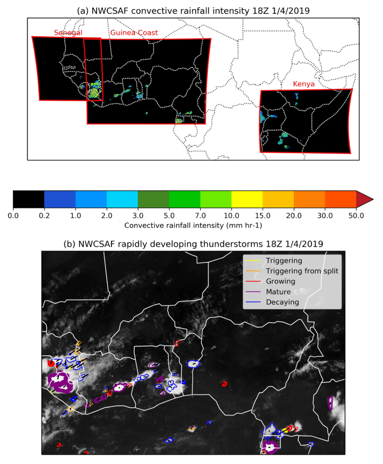
Figure 1: Examples of the two products analysed in this study. (a) shows the convective rainfall rate and (b) shows the rapidly developing thunderstorms convection-warning product over the Guinea Coast region.
The study demonstrates that both provide useful information, despite some limitations. The convective rain rate product has valuable skill for predictions at least 90 minutes ahead (Figure 2). This could be used for example to inform flood warnings, or disaster response. The rapidly developing thunderstorms product can also identify the occurrence of heavy precipitation, correctly identifying around 60% of strong (5 mm of rain per hour) events at least one hour before they occur. For example, this could be used to inform warnings to fishermen and other vulnerable water users.
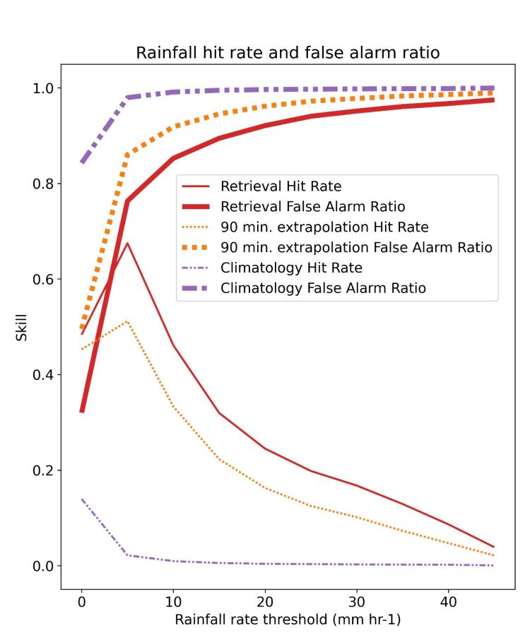
Figure 2: Skill metrics for the convective rainfall rate product, compared to predictions based on the historical occurrence of rainfall events. Hit rate means the proportion of true rainfall events that are successfully identified, and false alarm ratio means the proportion of the predicted rainfall events that do not occur in reality. “Retrieval” here is the skill of the satellite products, versus higher quality data. This higher quality data is regarded as “truth” but is not available sufficiently quickly to be useful for nowcasts. The “extrapolation” is the forecast made by extrapolating the observed storms forward in time. The “climatology” skill is skill from assuming today’s storms can be predicted using previous years storms on the same time of day and time of year.
The analysis is crucial in allowing forecasters to have confidence in use of the products which GCRF African SWIFT has made available to them to issue warnings. It has also highlighted some aspects of both the convective rain rate and rapidly developing thunderstorm – convection warning products that could be improved upon. Future work will aim to further develop these products to provide better nowcasts for tropical Africa.
Ongoing work within the African SWIFT project is also enabling African groups to generate these products locally, as well as supporting forecasters to understand and use these products effectively to minimise adverse impacts of severe weather on lives and livelihoods in Africa.
Paper Information
Hill, P. G., Stein, T. H. M., Roberts, A. J., Fletcher, J. K., Marsham, J. H. & Groves, J. 2020. How skilful are Nowcasting Satellite Applications Facility products for tropical Africa? Meteorological Applications, 27(6). DOI: https://doi.org/10.1002/met.1966
About the Author
Dr Peter Hill is a researcher at the University of Reading. As part of the African SWIFT project he is using satellite observations to improve understanding of the physics of storm systems over tropical Africa. Dr Hill began his career at the UK Met Office where he was tasked with improving the way weather and climate models represent solar and thermal radiation, before moving to the University of Reading where he was first introduced to West African meteorology as a researcher on the DACCIWA (Dynamics Aerosol Chemistry Cloud Interactions in West Africa) project.